 Facebook
  Twitter
  Soundcloud
  Youtube
  Rss
Rss 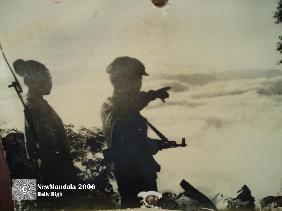
Two soldiers look out over a valley of mist. Kaysone Memorial Cave Office, Vieng Say.
In my previous posts, I mentioned Mentur, and his part in the resettlement of the Hmong in and around Vieng Say. His story raises many questions: what made a man’s search for subsistence into an illegal trespass? Why it was possible for the resettlement program to be enforced? What logics of legality and illegality led to his incarceration? To answer these questions, it is important to understand first how land is owned and regulated in today’s Laos. Fortunately, the staff of the Vieng Say lands office were extremely helpful in explaining this to me.
Essentially, there are two ways of owning land, they explained. The most common is to pay land tax. In this arrangement, the person occupies a piece of land that no one else claims, and that has not been classified for any alternate use (such as a reserve or a state forest). Occupation is defined in terms of use: the person needs to build structures, plant productive trees, establish wet-rice fields, create a fish pond, or establish some other kind of enduring productive activity on the land. The lands office staff used terms like “development”, “improvement” and “investment” to define what counted as “land use” under this arrangement.
The person occupying the land must pay an annual tax according to the size of the property. In return, that person is given a “baay sia pha sii” (a notice of tax payment). This serves as the only legal documentation of their rights to the land. Such rights are not absolute however: they are dependent on the person making continual use of the land. If a person fails to establish enduring productive features on the land, the authorities (starting with the village chief, then the Lands Office, and eventually the police) will warn the occupant to make some use of the land. If the occupant fails to comply, they will lose the right to pay tax on the land, and thus lose their only right to the land. The Lands Office staff explained that the land would then be made available to poor people to use and pay tax on.
A person paying tax on such land is not in a position to sell it. They can only sell the rights to their investments on the land – the house built on it, or the fruit trees planted there, or the rice fields and irrigation system established. By selling the improvements made on the land, the owner is essentially selling the right to pay tax on the land. The land itself belongs to the government.
If you have successfully paid tax on and improved your land, you may buy the second form of ownership, a “baay moop sit” (a notice of transfer of rights). This notice is purchased from the government, with the price gauged according to the location of the land and its size. In Vieng Say town, 1 square meter costs 1000 kip. In outlying regions, one square meter costs 600 kip. Once this notice has been purchased, the land cannot be reclaimed by the government, even if the owner does not use it or improve it any further. The owner continues, however, to pay tax on the land. The baay moop sit may also be sold.
When I asked about the situation for resettled Hmong villagers, the office staff explained that upland fields all belong to the government, in the sense that the upland farmers pay tax on the land but none of them to his knowledge had purchased the rights to their upland fields. I pointed out that on the slopes of an upland field, it is (almost by definition) impossible to establish a wet-rice field. It would be very difficult also to establish the other kinds of “improvements” that office staff had listed as evidence of rights to land: a fish pond, fruit trees, houses. From what I observed of the upland fields in and around Vieng Say, however, Hmong tend to farm rice on an upland field for only one or two years. The fruit trees they establish tend to be of the temporary kind, such as banana trees. At the end of the harvest, the remaining stalks of the rice or corn are burnt, their ashes returning nutrients to the mountain soil. The fields are then “improved” by being left fallow. The forest regenerates quickly: I walked through fields thick with saplings that towered above my head that my guide identified as only two years fallow. Given a sufficient time to regenerate, the upland fields exist in a productive symbiosis with forest plants.
But lands office staff did not recognize this form of land management as “development”, and therefore as not indicating ownership. For Land Office staff, ownership is initially defined through “use”, but only certain kinds of uses count: things like permanent structures, perennial productive plants, and irrigation. These are precisely the kinds of “use” not found in upland fields. When I asked directly if cultivating upland fields counted as “investment”, “development” or “improvement” of the land involved, the Lands Office staff dismissed it out of hand. “They just cut the forest down, grow rice and that’s it. That is not improving the land.” In the quasi-legalese of the land tax system, upland field cultivators only have the right to pay tax on, but never to ensure secure ownership of, the fields that they cultivate and the forest that they nurture into regeneration. When I asked if the Hmong could sell their upland fields, he laughed and said, “no one would want to buy them. Maybe if they grew an orchard, they could sell that.” But from the stories told to me in the resettlement villages, it was clear that there was another value being but on Hmong land: not its value as agricultural land, but as forest to be either conserved or logged.
Increasingly large blocks of land in Laos are being allocated as forest reserves or state forests. This raises the question of classification. Although the land tax system commences with an image of unclaimed or unclassified land, a pioneer proceeding into the wilderness and establishing ownership through “use” over unused land, increasingly very little land is left unclassified. The land frontier is closing rapidly. In Vieng Say town previous to 1992, for instance, people established houses as they pleased. But since that time, a new system has been in place that regulates how and where people can settle. In the new developments planned for extended suburbs, for example, the government has stipulated that new houses will be ordered in 20 by 20 meter (400 square meter) plots in straight lines following an orderly, grid-like pattern.
In rural villages, too, a complex system of land classification has been introduced. In every village I hiked to around Vieng Say, I saw a sign, most often signed by the “MCC” (the Mennonite aid group). This mapped out the village and surrounds, clearly marking the border between their outlying lands and those of neighbouring villages. These maps also marked out the different land classifications of the area. The different classifications for land marked on these maps and noted by Lands Office staff were: forest reserve, state forest, recovering forest, overused forest, and land for “use” – productive land. It is this last category, productive land, that is available to households for agricultural production. The resettlement villages are allocated a region of productive land, and it is up to the resettlement village residents themselves to allocate land to each household. Each family is allocated about half a hectare, according to Lands Office staff. It is also up to the village to pay land tax on their productive land as a unit, collecting from each household and paying as a lump sum.
The practice of classifying all land as one sort or another has become standard in contemporary Laos. This has the effect of squeezing settlement options for the poor down to a few prescribed areas. Furthermore, the practice of defining ownership in terms of “use” (and a very narrow definition of “use” at that) leaves many Hmong unable to prove a legally sanctioned authority over the upland fields that they cultivate and leave fallow, and the forest that forms an integral part of their productive activities. This dual process of classifying and defining establishes a logic that makes the resettlement on the Hmong appear not only legal but laudable to Lands Office staff.
When I asked about a specific resettlement process that I had heard about, where Hmong were relocated from a region closer to Vietnam into the Vieng Say District, a Lands Office staff member explained that the Hmong were moved out of the region because it had been reclassified as a forest reserve. It is now a big forest, he explained. Kathing (wild ox) had been sited there. The Hmong had been “destroying” the forest. There were lots of people living there, he said, and they were at least ten kilometers from the nearest road. The only way to reach them was on foot. They were far from schools, hospital, and electricity. So the people were moved, and now no one is allowed to live there.
Ideas here of “conservation” for the forest and “development” for the people combine with particular definitions of use and classifications of land to drive the Hmong from their upland fields into the valleys of Vieng Say.