 Facebook
  Twitter
  Soundcloud
  Youtube
  Rss
Rss 
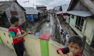
Earthquakes, much like lightning, can strike the same place again. This point was tragically driven home in Cianjur in West Java, when it was struck by a deadly earthquake on 21 November 2022. The same area was heavily impacted by an earthquake on 28 March 1879. The same immediate region in West Java was again struck on 14 January 1900, impacting the nearby town of Sukabumi. Therefore, knowledge of where an earthquake has occurred in the past, and how large it was, is crucial. This forms a valuable input into modern seismic hazard maps. These help to determine how buildings and other critical infrastructure need to be safely constructed in a particular region. Reliable records of past earthquakes for the purpose of seismic hazard can be acquired from instrumental records. But on a geological time scale, the length of the instrumental record is short (~120yrs). It is, therefore, supplemented by evidence of earthquakes that occurred before instruments were available that are preserved in the geological and/or written historical record.
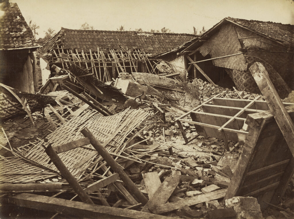
Damage in the Chinese district of Cianjur as a result of an earthquake on 28 March, 1879. (CCL in the Southeast Asian and Carribean Images Collection of KITLV)
Such inputs are vital to understand seismic hazard in Indonesia. It is among the world’s most densely populated countries and is also very tectonically active. This makes it particularly vulnerable to frequent earthquakes that can have major socioeconomic impacts, as we saw in Palu on Sulawesi in 2018. While the instrumental and geological record has been and continues to be investigated in Indonesia, little work has been done to systematically re-evaluate historical earthquakes in the archipelago for close to three decades. This includes locating and analysing written descriptions of shaking effects during earthquakes.
For these reasons, my co-authors Phil Cummins, Aron Meltzner, and I explored the historical earthquake catalogue for Indonesia in our recent study published in the Bulletin of the Seismological Society of America. We called our database the Gempa Nusantara database (also available via GitHub) which is collection of felt shaking intensity, or macroseismic intensity, observations for 1,200 earthquakes in the region of Indonesia spanning four centuries from 1546 until 1950. The name of our database which means “Earthquakes of the Indonesian Archipelago” in Bahasa Indonesia is derived from a combination of the Indonesian words for “earthquake” (gempa bumi, shortened colloquially to gempa) and “archipelago” (nusantara).
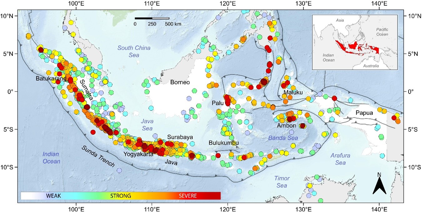
Figure 1: Colour filled circles display each of the 7380 macroseismic observations in Gempa Nusantara with colour bar indicating severity of shaking (inset: location of Indonesia in red).
In our study, we sought primary documentary sources from the colonial period in Indonesia. This was driven by the fact that many modern catalogues of historical earthquakes for Indonesia can be affected by inconsistencies that stem from a reliance on unvetted sources and/or the unwitting repetition of errors in earlier catalogues. In fact, many of these catalogues are by-products of a multi-lingual historical earthquake catalogue compiled by a German earth scientist, Arthur Wichmann. His work covers two periods: prior to 1857 and from 1858 to 1877. But these modern catalogues often fail to consult the primary sources used by Arthur Wichmann, nor do they add new information from unused primary sources such as historical newspapers.
The documental material we examined included those available to Arthur Wichmann such as colonial Dutch journals and official reports of post-earthquake damage reconnaissance. We added to this collection, new information gathered from other previously unused sources such as colonial Dutch newspapers and transcriptions of official correspondence by the Vereenigde Oostindische Compagnie or VOC (also known as the Dutch East India Company). Like the Wichmann compilation, and all modern catalogues derived from it, the sources for our study are largely derived from colonial sources, with one exception. Information on earthquakes from such sources diminish greatly during World War II, when Indonesia was occupied by Japan. However, we were able to fill this gap by searching archives of local Indonesian newspapers from this period.
To classify the severity of shaking during earthquakes in the absence of instruments we use an intensity scale called the European Macroseismic Scale (EMS-98). This allowed us to convert the descriptive observations we collected to numeric data. The EMS-98 scale is similar to the relatively well-known Modified Mercalli Intensity (MMI) scale. The different colour-coded circles displayed in Figure 1 indicate weak (cool colours) versus strong (warm colours) shaking for all 1,200 earthquakes in the Gempa Nusantara database. Very damaging shaking is displayed as darkening reds.
Given that Indonesia is prone to very large magnitude earthquakes and that it covers a region comparable to the east-west extent of Europe, it was surprising that reports of damaging shaking were few, accounting for barely 2% of all 7,380 macroseismic observations. Yet a handful of extreme observations exist such as for an earthquake in Ambon in 1898 which literally threw people several metres and even shifted heavy cannons. In other cases, the original materials we sought also helped bring about clarity. For example, an inaccurate translation from German to Dutch by Arthur Wichmann misled his contemporaries that an earthquake in 1820 in the Flores Sea made cannons “bounce” upon their gun carriages at Bulukumbu in southern Sulawesi. Material we found showed this to be factually incorrect. While the earthquake shook the cannons in questions, it did not produce as violent vertical shaking as was previously assumed.
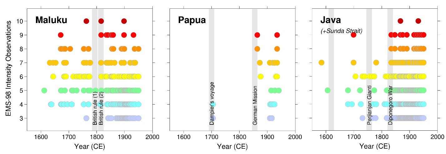
Figure 2: Chronological differences in the completeness of macroseismic data for Indonesia.
The historical record is known to be influenced by geopolitics and socioeconomics. Given that our source materials were largely in European languages, and almost entirely from the Dutch, it was no surprise that the chronologically longest written records of felt earthquakes are from regions where the VOC established trading posts, that is, in western Java and in the Maluku region as can be seen in Figure 2. Observations from these regions increase after political control shifted into the hands of the Dutch. This contrasts with the written record of felt earthquakes in regions known to be very seismically active such as Papua which remained outside the Dutch sphere of interest until the early 20th century.
In the Gempa Nusantara database, we documented 1,200 earthquakes. This is a significantly greater number in comparison to those known previously. In three rare cases, we could discriminate the causative fault lines that were responsible for historical earthquakes in Sulawesi in 1909 and on Sumatra in 1892 and 1933. We also uncovered evidence for an undated tsunami in the region of Palu Bay in the 1800s. A particularly unexpected find was the discovery of severe liquefaction in rice fields near Batukarang on Sumatra in 1936. These press accounts from Sumatra were reminiscent in both description and spatial extent of the catastrophic liquefaction observed in the Palu region in 2018. We were also able to show for the first time that paleoseismic markers examined by paleoseismologists in coral microatolls along Sumatra’s west coast (Figure 3) preserve only the largest megathrust earthquakes. Smaller events known only from the historical record can often be hidden depending on the location of their source zones or are overwritten by larger climate signals also preserved in coral microatolls.
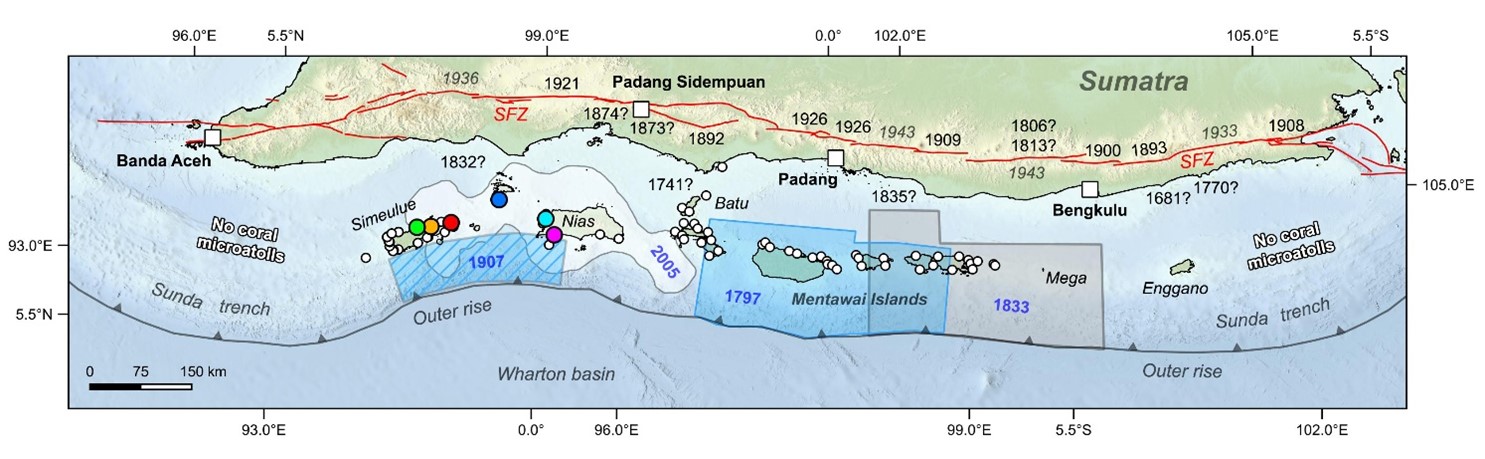
Figure 3: Locations of historical earthquakes ruptures on the Sunda Megathrust and on the Sumatran Fault (SFZ) along with coral microatolls (white and coloured circles) examined in the past by paleoseismologists.
Crucially, our dataset of numerical observations allowed a simple evaluation of the latest version of the 2017 Indonesian seismic hazard map (Figure 4). Using observations from out dataset, we calculated how often a certain level of intensity occurred in any given year in 12 Indonesian cities. This was compared with independent models from the 2017 Indonesian seismic hazard map to predict the same information for those same cities. The correspondence between observations and the hazard curves was good for some cities such as Surabaya. But for others such as Yogyakarta, it appears that damaging shaking occurs more frequently than the modern hazard curves suggest. We speculate a number of reasons for this ranging from, but not limited to, yet-to-be mapped faults and to the poorly known rates at which mapped faults move. It is not uncommon for future seismic hazard maps to be updated as newer, more accurate data becomes available and we believe the Indonesian hazard map will be the same.
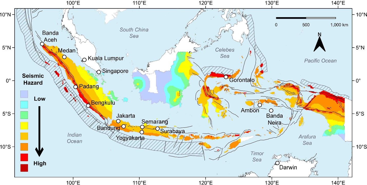
Figure 4: The 2017 National Seismic Hazard map for Indonesia.
The well-known naturalist James Hutton stated, “that from what has actually been, we have data for concluding with regard to that which is to happen hereafter.” This applies broadly to research in general but also to the collection, curation and collation of written documentary materials pertinent to the study of historical earthquakes. Much work remains to be done on the historical earthquake catalogue for Indonesia that taps non-European sources, both local and regional, on the lines of recent historical investigations of Indonesian manuscripts. Our work on Gempa Nusantara demonstrates how a carefully vetted and well-documented historical record not only complements studies of seismic hazard but is itself an important standalone tool for the study of earthquake hazards. We hope it will ignite further research and policy conversations about seismic hazard in Indonesia.