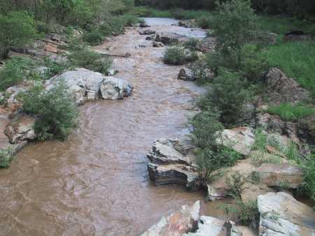
The longer Thailand’s flood crisis goes on, the more commentators (both in Thailand and internationally) resort to the old belief that deforestation has contributed to the flooding.
This is a very complex issue, much more so than many of the simplified statements in public commentary would suggest. There is no doubt that forested landscapes can often absorb more rainfall than non-forested landscapes, especially if forest clearing is associated with soil degradation and the creation of hard surfaces such as roads. But even very absorbent forested landscapes have their limits – either when the rainfall is particularly intense (falling faster than it can be absorbed) or when the forest soils become saturated with water and simply cannot absorb any more.
As I have noted previously on New Mandala, it is well to remember that flash flooding in Thailand is commonly referred to as nam pa (literally, forest water).
To the extent that there is any consensus in the literature it is that while forest cover may have some effect on flooding at a local scale, its effect at a large scale, and for high-intensity events, is likely to be much more limited. Here is a selection of quotes from some recent surveys of relvant literature. First, some quotes from Ian Calder et al, Forest and Floods:
Consulting the state of scientific knowledge clarifies the factual basis for understanding forests and floods. And indeed there exists a clear gulf between this knowledge and public perception. On the one hand we have science, which admits complexity, incomplete knowledge, uncertainty qualified by caveats, and sadly a very unexciting story: a story that the media and popular press are unlikely to consider even on the “worst of news days,” and on the other hand the simplistic, yet highly dramatic, public perception. (92)
From theoretical considerations it would be expected that interception of rainfall by forests reduces floods by removing a proportion of the storm rainfall and by allowing the build up of soil moisture deficits. These effects would be expected to be most significant for small storms, where the soil moisture or interception “deficit” might be a significant proportion of the storm rainfall but relatively insignificant for the largest storms. (89)
Storms of sufficient spatial scale to saturate large basins are likely to be of the largest magnitude and for
these extreme event storms the effects of land use change on flood response are expected to be least pronounced. (90)Thus, the evolving science perception suggests that the role of forest cover in flood mitigation or management is circumscribed. Perhaps the most salient point is that as the severity of the flood increases the marginal impact of land use change appears to be reduced. Still, this perception is evolving. There remains a need to better understand the interrelationship between different hydrological functions that are impacted by land use change, such as between sediment, the build-up of river channels and flood heights. In addition, as scientists improve their ability to disaggregate the linkages between forest and non-forest cover (such as roads) impacts associated with particular economic activities, the alternatives for minimizing associated
flood risk will become clearer. (92)
And here are some quotes from van Dijk et al Forest–flood Relation Still Tenuous:
A peak flow enhancing effect of forest removal has been observed in small-scale … experimental
studies. Small to medium peak flows (i.e. the more common, less damaging ones) appear affected most, while the largest events do not change noticeably (e.g. Hewlett, 1982; Bowling et al., 2000). To date, studies in larger basins have not usually found any changes after deforestation of up to 50% of the catchment, and where changes did occur, these were not directly attributed to deforestation (reviewed in Bruijnzeel, 1990; Wilk et al. 2001). (112)In summary, our understanding of the influence of deforestation on hydrology is far from complete, but to date, there has not been convincing empirical evidence or theoretical argument that removal of trees is likely to exacerbate severe flooding in developing countries (or elsewhere). (112)
Strong statistical correlation was indeed found between population and flood frequency, for country totals … as well as after dividing by area …. Conversely, correlation between forest cover or cover loss and flood frequency appears absent. … After accounting for the correlation with population, forest cover or deforestation appeared to explain less than 1% of the remaining 17–30% of variation in country statistics. (113)
Both papers highlight the degree of uncertainty around some of these issues, and the need for future research. But the overall message is clear – assuming that forest clearing is a significant contributor to flooding on the scale that Thailand is currently experiencing is likely to result in inappropriate and ill-informed policy responses.
Didn’t the Thai government end logging in the country in the late 1980s as well? One would think that this drastic measure might have mitigated some of the effects of the floods. Of course that wouldn’t account for the loss of forests due to agriculture or urbanization, but it should have made some major difference.
0
0
Evan #1
Did forest clearing contribute to Flooding in the USA?
Did forest clearing contribute to the flooding in Australia?
Did forest clearing contribute to flooding in the …. please fill in any country’s name in the past three years.
It is the weather change and the massive amount of rainfall. Talk to any planner and they will “plan” for 50 years rain or in a worst case scenario 100 years rain. Which means the highest rainfall in a 50 year period or 100 years period.
The current rainfall (please look at earlier post on rainfall) has blast the 50 years / 100 years rain to smithereens
0
0
Hi Andrew,
In my opinion, what is remarkable is the relative scarcity of causal claims linking floods to deforestation in the English Press in Thailand over the last few years (with the exception of the letters to the editor section). This is the case not only for the current floods, but also for many flooding events last year and two years ago, in particular those where the area flooded was located directly downstream from what could only be labelled good quality forest (ex: Khao Yai NP).
A few months ago, I did a little analysis with my endnote database, which suppported this view.
If I understood correctly an allusion made last month in Toronto, this view is also shared by a certain scholar with whom you have recently worked.
0
0
Well there are forests and forests. So which ones are we talking about? And then there are, or were, grasslands.
Different vegetation communities differ in their ability to hold the soil which acts as a major water reservoir, far more important than dams and also to slow the passage of water.
So for example the Themeda grasslands at Cooper Street on the Merri Creek in Melbourne hold rain water for many hours while golf courses fail to do this.
A winding stream with a riparian forest similarly slows down and spreads the flow across the landscape far more gently than a channelised stream.
The Democrat Government with Chart Thai Pattana in command of the Irrigation Dept spent millions of baht, in a program that still continues, channelising streams and destroying riparian forests thereby speeding the flow of waters towards central Thailand.
0
0
I believe that there is no question that deforestation contributes to the frequency and severity of flooding. It is scientifically proven how much water the roots of a tree can retain, and just common sense tells me that water runoff, particularly on a slope, must occur at a greater intensity post versus pre-felling of trees. I can see the argument that water runoff becomes more significant with severity of storms, irrespective of the existence of forests, but that again seems to me to be common sense and not an argument against the impact that deforestation has on water retention.
Consider the reverse observation made by Welsh farmers, as described in a Guardian article in 2004 (http://bit.ly/qB94nT): “They had noticed that during rainstorms their newly planted woodland seemed capable of absorbing vast quantities of water while grazed land let rain pour down hillsides…..Water will always move down a hill, either over the surface or through the soil, but this way (they) could stop it all arriving at the same time. Major surges would merely become heavy flows.” Again, common sense?
Not even 200 years ago, Thailand used to be a densely wooded land, forcing the population to live along shorelines and waterways. Subsequent logging has taken care of much of these tropical forests. But deforestation is a fact of life, well-known to Thailand for many years. We need to point the finger to a combination of factors, such as: severity and frequency of storms (natural causes); deforestation; loss of natural rain catchment areas as a consequence of urban planning (or lack thereof); and atrocious and politicized water management, all of which have created a “perfect storm” in 2011.
0
0
In all this discussion of forests, aren’t we missing another significant landscape? that would be fens, bogs, marshes, swamps – in short, wetlands. These are far more significant reservoirs of water in intense rain events. Old forests, as I have personally observed many times, don’t hold that much water in heavy rains because the ground is nearly bare (no light to the forest floor). But if it’s all sweeping down into wetlands, then it’s being held there before gradually seeping out to the surrounding lands. I saw a great demonstration of this just this week in the restoration of wetlands along Lake Michigan in the upper midwest of the United States. Restoration of these wetlands has greatly reduced the impact of intense rain events in the region.
And, of course, what do we do with wetlands in Thailand? Oh, yes, cover them over for roads, build rice fields, clear them out for shrimp farming …
0
0
It seems that there are definitely 2 sides of the story here, very relevant shares on the argument for logging having an impact on severe flooding, particularly if you fill out the equation with grasslands, wetlands etc. The question may come to what size of development (and destruction) is required to have a signficant impact. And then more questions come up. In the English press in Thailand the role of development has been referred to as an important factor, particularly when you have canals built over, waterways redirected or built over, waterrsheds being built over. So perhaps the discussion needs to be more focused on development issues, and sustainability issues. Interesting discussion in the context of climate change and recessions that could lead to depressions.
0
0
To Stephen Wiedemann: check out the writings of L.A.Briunzeel, Ian Calder, and others, who are hydrologists. They argue the connection between deforestation and flooding might appear to be common sense, but there are four important controlling factors that are less visible: (i) the amount of rain (see previous posting to this site); (ii) the absorbptive capacity of soil whether it is covered by trees or not (ie compacting soil increases run off; whereas non-compaced soil can be just as absorbing as soil under forest, if not more so); (iii) the amount of paving or compacting of roads and surfaces in basins; (iv) basin morphometry (ie the ways tributaries all connect to one big river quickly). In Thailand, the Chao Phraya and associated basins are really connected to one end point (ie morphometry plays a role); soil compaction and paving is increasing all the time (but it is difficult to measure); and forest cover has increased (if you include plantations). The problem with blaming deforestation is that it allows the government to use this argument to increase the number of plantations. But this does not necessarily increase the absorption of water: indeed Calder’s work (not in Thailand) suggests plantation forestry can *increase* runoff and compaction.
0
0