 Facebook
  Twitter
  Soundcloud
  Youtube
  Rss
Rss 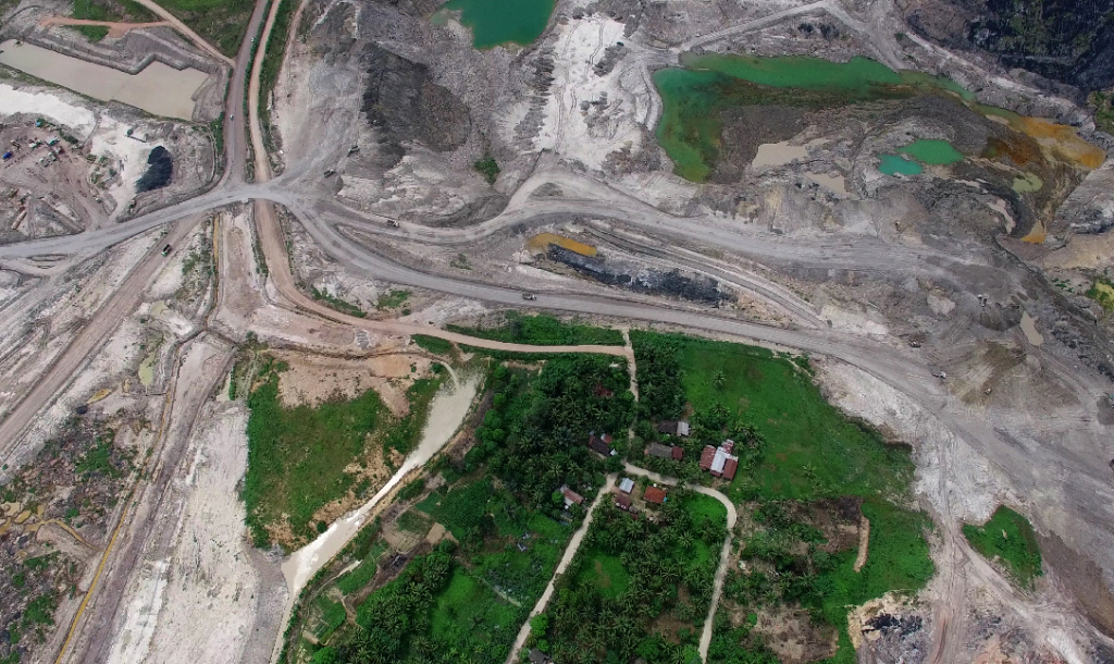
What can the 2014 Village Law contribute to addressing land conflicts that are ever more rampant in Indonesia’s rural frontier areas? In West Kalimantan, the Village Law has inspired new initiatives to reclaim control over village territories that are contested by large-scale land investments, such as oil palm plantation projects.
Much has been made of the perils and pitfalls of Indonesia’s 2014 Village Law.
But, to grasp the successes and failures of the Law, we need to also look at the diverse initiatives that are developing in villages across Indonesia in response to the legislation. In reality, the law has a lot more to offer than direct cash injections into village treasuries.
For example, in Indonesia’s Kalimantan region, the launch of the 2014 Village Law is seen as an opportunity to protect indigenous land rights from large-scale land investments. And these important initiatives are being driven by drones and novel forms of map making. The law legitimises village level spatial planning based on participatory mapping, leaving village governments better positioned at the negotiation table against state and private actors.
This is essential work given recent changes to agriculture in the area.
The new millennium brought a wave of oil palm plantation expansion in West Kalimantan. In Sambas district alone, 202,331 hectares (ha) have been surrendered to 35 oil palm companies since 2004, causing land conflicts between companies and communities.
Since 2006, Sungai Putih village has been in conflict with an oil palm company over a 20,000 ha plantation project that targeted land in 12 villages. The villagers resisted the plantation project, which largely overlapped with their rubber gardens and rice fields. They did not want to give up their lands to the company and become labourers on their own lands instead. After a mass demonstration, the company eventually ceased its operations.
Lately however, rumour has it that new oil palm companies are eyeing the area again. In response, the village government invited the NGO Lembaga Gemawan to initiate a ‘participatory village mapping program’, which will chart village borders and document current land use patterns. The village government claims that the Village Law legitimises village level spatial planning and hopes that this will provide them a better position at the negotiation. This information will be used to protect village interests in light of any plans to develop land in Sungai Putih.
Using drones and GIS techniques, the mapping team identified the village borders and documented current land use practices. The next step will be to design a village spatial planning, dividing the village in different land use zones, such as rubber gardens, rice fields, mixed-crop gardens and residential area. This spatial planning will be laid down as a village regulation, which will formally take effect after being signed by the district head.
Thereafter, land use zones cannot be converted to other types of land use without the permission of the village government. Companies will no longer be able to directly negotiate land transfer with individual land owners, or with village officials behind closed doors.
‘Participatory mapping’ is a popular term among NGOs in Kalimantan. It is not a new trend; mapping programs were in fact initiated during the New Order to counter land dispossession by government and private companies. However, ‘mapped land’ is not completely immune to appropriation. In fact, often village elites themselves facilitate land transfers to companies. Moreover, companies could also use these maps to identify available land and resources.
So how can mapping protect land rights?
First, village maps and detailed spatial planning can help villages to consider whether land development projects are in their interests. Second, companies often use maps from the district government that reveal nothing more than the coordinates of the concession borders. Lacking any detail on villages and land use practices, these maps provide companies with a ‘clean slate’ to develop plantations on. Village maps and spatial planning can be used as leverage by communities in negotiations with companies who often only listen to the language of documents.
There are still many challenges for villagers to secure their rights. For example, village regulations can be nipped in the bud by district governments who have other plans for the village lands. Moreover, genuine participatory village spatial plans depend on the goodwill, capabilities and networks of village officials. Past experiences indicate that village officials are not always very interested in protecting the land rights of villagers. A map is just a piece of paper when village governments fail to use it in the interest of their villages.
In fact, the 2014 Village Law does not necessarily offer landslide improvements for the acknowledgement of land rights for rural communities. However, within the current wave of public debate about changing rural Indonesia, the Village Law has inspired new initiatives to reclaim control over contested territories.
Rosa de Vos is a Phd Candidate at Wageningen University. Her research concerns land tenure changes in context of large-scale oil palm plantation development in West Kalimantan.
Laili Khairnur is Director of Gemawan, a local NGO in West Kalimantan that focuses on human rights, good governance, ecological justice and gender justice issues.
Hj Iskandar is a local leader of Sungai Putih Village who assists the community with governance capacity building.